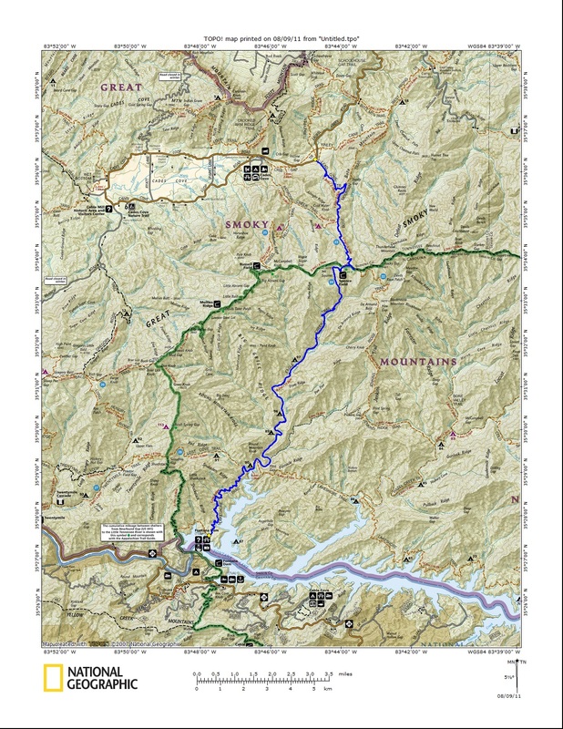
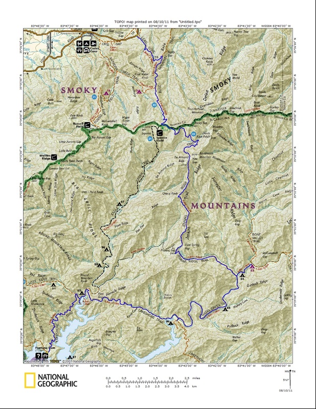
With the number of remaining hikes left to do dwindling, the time was right to make the jaunt up and over the AT from Cades Cove to Fontana for the second time. It would be a much shorter trek this time around, and more refreshing, as I would head down Eagle Creek and enjoy its numerous unbridged crossings. 
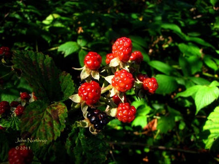
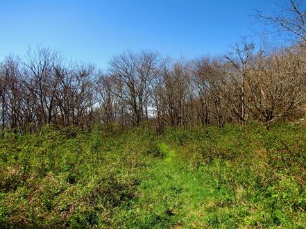
Blackberry patches are opening up all across Spence Field. 
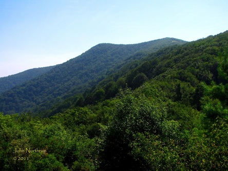
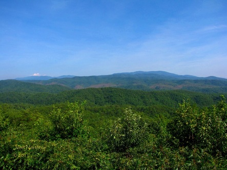
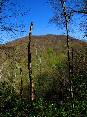
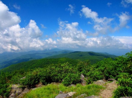
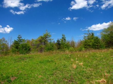
A rather clear morning standing at the base of Thunderhead. 
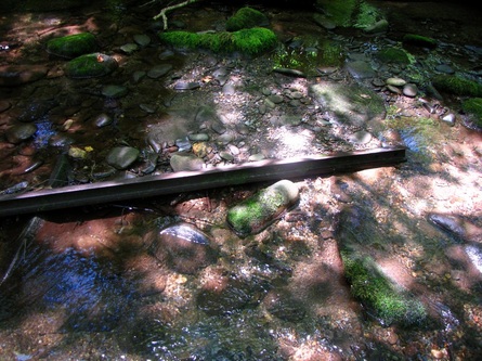
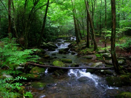
There are a great deal of artificats along Eagle Creek. This is a bent piece of train rail lying in the creek. 
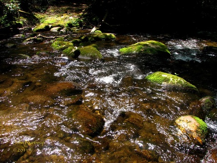
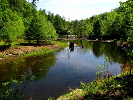
One of twenty stream crossings, this one third from the end where the sun glimmers in the water. Sometimes I would find the deeper places to stroll through because it felt so nice on the legs and feet. 
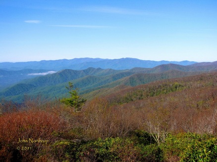
Looking out from the Foothills Parkway, that brown scar you see is the path of the EF-4 Tornado that struck the park back in the spring, devastating several of the western trails. Beard Cane, Hatcher Mountain, and Rabbit Creek trails remain closed at the moment because of it.
1 Comment
Call me crazy...a 31 mile body buster from Cades Cove to Bone Valley to Fontana. A few serviceberry trees were still in bloom despite the morning frost. Views to the southwest toward Shuckstack and Fontana were pristine. A break in trees affords a view up at Blockhouse Mountain. At one point the trail passed through a tiny forest of painted trillium...most impressive. A grassy and blackberry adorned Haw Gap. Peering across the porch of the Calhoun Place near the old Proctor settlement. Glasslike waters of Eagle Creek before it empties its waters into Lake Fontana.
After my lengthy hike yesterday, I was surprised at how good I felt. Nothing was sore or stiff, and I wasn't tired. This morning, though, I was slow to get moving. I got a later than usual start up the West Prong Trail out of Tremont but I was alright with that since today's hike would be smooth sailing compared to the last two days. I hadn't done this trail before, and I still had the middle section of Bote Mtn. to complete, so a simple up and back kind of morning was in store. Right from the start, there was a side trail leading to a cemetery, but I neglected to follow it, choosing to hit it on the way back. The first mile of West Prong is all up through open woods and broad hillsides. Very few wildflowers could be seen in the dark, green forest. After leveling out for a quarter mile, the trail descends a few hundred feet to a feeder creek crossing and then over a long footbridge over the West Prong. The bridge provides a safe crossing, offers a pleasant view of the river, and unites the two halves of campsite #18. This campsite is well kept and situated in a small gorge with sounds of the West Prong filling the air. Upon leaving the campsite, the trail again heads uphill, but this time it would last all the way til my turnaround at the junction with Lead Cove Trail. West Prong eventually comes out atop the ridge to meet up with the Bote Mtn. Trail, the former roadway that led up to Spence Field. Bote Mtn. is steep in places and level in others, and almost always rocky. At least the path is wide; thus, discouraging spiders from constructing their pesky webs across the trail. Views are limited to the few openings were old wildfires ripped open the forest canopy. The ridge here is very dry, covered in pine trees, and the dirt is red like the rocks of Sedona, Arizona. At this point, wildflowers that could be seen were erect and canada goldenrod, wide leaved sunflowers, and the occasional Hercules club. Views could be seen down into the valley of the West and Middle Prongs and up the slopes of Thunderhead Mtn. whose peaks were clouded in today. The heat was more prevalent today and it was welcome relief to finally reach the junction with Lead Cove and catch a cool breeze from time to time. Still a long day ahead of me, I didn't linger and quickly headed back to Tremont. As promised on the way back, I took the side loop to the Walker Family Cemetery which actually looks down upon the parking lot for West Prong. It is an impressive cemetery to say the least, with a carefully crafted wooden fence and entrance gate. There was a decent path around the gravestones and the fake floral arrangements were everywhere, brightening up the dark surrounding woods. Most of the names included Walker, Stinnett, Moore, and McCarter, some old, some young, some from the past, others just recently passing. I was also impressed by the obvious loop trail that one could follow to get there. In so many places throughout the park, cemeteries are hidden, overgrown, poorly situated, and disregarded. But this one is certainly looked after by the families and the park which was nice to see. The conclusion of today's hike and my eventual return to the mountain marks a fifty mile week. One that saw me knock out seven different trails in the park and put me well over the 400 mile mark out of the park's 900. I'm coming to the point where sections of the map are getting filled in fast. I only have one hike to do in places like Tremont, Elkmont, Greenbrier, Little River Road, Newfound Gap Road and Smokemont and those areas of the park are complete. Going by prospective hiking schedule, the month of September should see it done. But until then, I have the rest of August to enjoy on top of Mt. LeConte and out of this ridiculous summer heat!
Having already been to my favorite destination the day before, I probably could've gone the rest of the week without doing another hike and still been happy. But alas, other favorite hikes were beckoning and so was the fabulous weather. Since the azalea and rhododendron had already peaked across the park, it didn't matter which order I did my remaining hikes in other than those that required good weather and visibility for views. So the obvious choice for today was a return trip to Spence Field and Rocky Top along the AT. And the path I had planned to get there also meant no new miles would be added. My purpose for today's hike was to hopefully see the catawba rhododendron, flame azalea, and mountain laurel display grace Spence Field and the slopes of Thunderhead Mountain in unison. They typically peak there this time of year, but the crazy blooming schedule had me feeling skeptical. It was a sight I really wanted to see. I've been there in early July when the white rosebay rhododendron are in bloom, and I was just there the first week of May to catch the serviceberry trees kick off the arrival of spring at high elevations. I also look to return to this spot in October to soak in some fall color. So as you can see, Spence Field / Rocky Top is one of my favorite destinations for several reasons across several seasons. It was recently my No. 2 on my all-time Smokies list of favorites, but got passed up by the spectacular trip out to Hemphill Bald via Cataloochee Divide. Today I would give it a chance to regain its stature, but much of that depended on the floral display. There weren't many miles to be traveled today, but I still wanted an early start to beat the traffic and enjoy the afternoon back in town with my folks. My ascent would begin along the Lead Cove Trail, a route that is all up and somewhat rocky from what I remember, but nothing too strenuous. It's also the shortest way to the top, convenient for what I wanted to accomplish. This stretch isn't even two miles so it passed quickly at my pace. The highlight along the way was seeing the first of the crimson red bee balm and a relative flower I had never seen before...basil balm. It's a smaller, white variation of the bee balm and I actually foudn more of it than the more common red. I reached the junction with Bote Mountain in no time, at which point I began to see more wildflowers alond the wide path, formerly and old road. Daisy fleabane, whorled loosestrife, purple asters, rosebay rhododendron, coreopsis, and lyre-leaved sage were in abundance. I even spotted some flame azalea which was promising. Shortly after the junction with Anthony Creek the trail ceases to be the old road becomes a narrower, dry, and very rocky route. At this point the only wildflower really doing anything was the galax. I was making such good time that I had already passed everybody that hit the trail before I did that morning...just like yesterday. It's always nice to get to a cool place first and be able to enjoy it in solitude, which also helps for taking people-less pictures. I knew I was nearing Spence Field because there a few switchbacks, but the major difference this time around compared to May was the filled-in canopy. My arrival on the AT kind snuck up on me just because everything was so grown up. The grasses in the field were taller and the numerous serviceberry trees were no longer white but green, also sporting their round red berries, a future feast for many critters I'm sure. As I made my way up through Spence Field, I spotted two turkeys grazing off to my right. Typically when I come across the big bird the freak out and fly away in a fury, but these two were tranquil and patient, so I slowed it down as well. Luckily they didn't mind my presence and I was able to get a shot of one. Pushing on ahead, my skepticism unfortunately became reality. The catawba rhododendron had already come and gone, the flame azalea were far and few between, and some mountain laurel was still lingering in places. Certainly not what I had seen in pictures and hoped to witness this day, but that's just the way it goes sometimes. Looking up towards Thunderhead with the early morning light in the background gave it a hazy and glary appearance with patches of light passing through the clouds. I knew the clearer views would be the west at this time of day, so I wasted no time making my way up toward Rocky Top for such views. The steep climb up Thunderhead was very different from the trek in May. The canopy went from bare to full, the woods from bright to dark and green, and the forest floor from all the spring beauties and trout lilies to just tall grasses and brush. I eventually reached the top and had the entire vista to myself. The views were a bit hazy all around, but not as bad as yesterday. The clouds also blocked Clingmans Dome and Mt. LeConte to the east. At least the panoramc to the west across the AT and down into Cades Cove and Fontana was visible. The climb to reach Rocky Top is a heck of a haul, no matter where you start, but when you get there, especially on a clear day, there isn't any place like it elsewhere in the park. Sure I was disappointed that I missed the peak bloom, but just being there was enough to make up for it anyways. I look forward to returning in the fall, in which I'll give it another chance at regaining the No. 2 spot.
All the anticipation of hiking in the month of May couldn't come without a little adversity. On my way down the mountain for a few days off, I managed to lose my footing on some very wet and muddy rocks, crashing hard and hobbling away with several scrapes. When I arrived at the motel, I did all I could to clean the wounds and begin the healing process. My biggest fear was infection, and that my right knee might require stitches. Thankfully nothing was bruised or broken, but I was worried what the morning might bring. Obviously personal health is priority number one, but I had one of my most favorite hikes planned for the next day. I had no choice but to sleep on it. When I awoke the next morning, I was amazed that nothing felt sore and that I had complete mobility. So I bandaged everything up and headed out as soon as I could, ecstatic for the day ahead. The skies were crystal clear and the temps warm. I thought the traffic for the drive out to Cades Cove would be heavy, especially with its recent reopening, but thankfully it was light. I would be heading up by way of Anthony Creek, for the last time I traveled to Spence Field via Lead Cove. Early on there were a lot of crested dwarf iris, foamflower, false solomon's seal, showy orchis, catesby's trillium, thyme leaved bluets, and yellow lousewort. The trail has numerous stream crossings, but this hiker greatly appreciated all the footbridges. A ways past Campsite #9, I stumbled upon a couple of deer staked out in the middle of the trail. Oddly enough, they wouldn't budge from their position, even as I proceeded to move closer and closer. I tried talking, then shouting, then quick movements and they just tilted their heads, stared, and probably laughed. Finally with the clanging of my trekking poles, they politely decided to move a few feet off trail and let me pass. One of them I could have reached out and touched if I wanted to, but figured it was best to just move on by. I kind of wondered if they had ever seen a person before since they were so tame. Bluets continued to dot the trail side up to and past the junction with the Bote Mountain Trail. The trail conditions became rockier and the ascent a little steeper. As I approached Spence Field and the AT, grasses, spring beauties, and violets were filling in the forest floor while trees became shorter and spread apart. My reason for choosing this hike at this time of year was to see the heralded display of serviceberry trees and their white blossoms that graced the bald and slopes of Thunderhead Mountain. I caught them right on in full bloom. They really stood out against the blue backdrop of the clear sky and the open meadowlike conditions of Spence Field. I took my time waltzing through the bald on my way to the base of Thunderhead soaking in my surroundings. Trees at this elevation are either leafless or just beginning to bud, so the colors of the serviceberry trees and a few others added some character to the otherwise colorless slopes of Jenkins Ridge and Thunderhead. The entire hike up to this point, my knee had been fine, but I was curious as to how it would hold up on the ascent to Rocky Top, which is about 500 feet in 1/3 of a mile. If you constantly stop to soak in the views like I do, you'll never get tired. Skies were deep blue, the valleys were coated in fresh greenery, and the higher elevations were still dormant, offering a unique contrast. The panoramas from Rocky Top were impressive as always. To the east, Mount LeConte and Clingmans Dome could easily be defined without the presence of haze. To the south stood Blockhouse Mountain awaiting the arrival of spring. To the northwest, one could easily pick out the loop road around the lush fields of Cades Cove. And to the west, you could follow the AT up from Fontana Dam to Shuckstack, to the junction with Gregory Bald, and across the ridges to Spence Field. Just a few reasons why this is one my favorite places to be. The fun didn't stop here, for I had more miles ahead of me that day. Descending Thunderhead went much faster than the trek up, for obvious reasons. It also gave me a chance to take in the sights at Spence Field one more time. Instead of turning back down Bote Mountain, I would remain on the AT and head out to Russell Field. The entire three mile section saw the trail lined with thyme leaved bluets, with several sections offering dense clusters of tiny blue flowers. I have always enjoyed ridge walking along the AT, and on a warm day like this, one's fortunate to catch a cool breeze that shoots up the from the valleys. Being so high up, the canopy was very open affording views of the park in all directions. Before arriving at the junction with Russell Field, I came upon two sections where the trail was lined with impressive displays of white fringed phacelia. The better came at McCampbell Gap where the thick, snowy looking blanket adorned the entire ridge and for a good distance. It made up for not seeing it at Porters Creek in April and catching it early at Low Gap. When I arrived at the Russell Field Shelter, I was surprised it hadn't been renovated yet. With its chain link fence still intact, a passing day hiker referred to it as a "nice bear cage." That's probably why it still looks the way it does. Now it was time for some serious downhill. Not far down from the shelter, one can take a spur trail out to the remnants of Russell Field. All that remains is a small clearing, relative in size to that of a little league baseball field. The encroaching tree line has obstructed any views. Now that the remainder of the day's hike would be going down, I had to alter my hiking style as not to irritate or worsen my banged up knee. Step logs were the worst, in which I'm so used to bending and pushing with my right leg, so having to adjust with my left leg was quite different. I made it down, though, without a fuss. After completing the loop with the Anthony Creek Trail, I made a quick stop at the campground store for some ice cream. It hit the spot and capped off a fantastic outing. I can't wait to revisit this hike in June to see Spence Field with all the mountain laurel, catawba rhododendron, and flame azalea in bloom.
The unusually wintery March and relatively dry month of April has kind of thrown the spring wildflower patterns out of whack. Some types of flowers have been slow to come to life while others have pulled through seemingly unaffected. Everywhere I've been this month, trillium, spring beauties, and anemones are prominent, while other notable wildflowers like white fringed phacelia and fire pink seem to be lagging relative to springs past. At least that's what my research tells me. So to be sure that I didn't miss anything on those renowned spring wildflower hikes, I had no problem visiting places like Chestnut Top and White Oak Sink three times each. It has been a treat to see these areas progress this month from bare, open woodlands with few early bloomers, to greenery that covered the forest floor, and most recently colors stretching from ground level up to the tree canopy. I got off to an early morning start in an attempt to beat the crowds and catch the slopes of Chestnut Top before the sun doused the slopes of the popular wildflower half mile. The white erect trillium and violets that greeted me at the trailhead during prior trips had now faded and been replaced by lots of foamflower, purple phacelia, meadow parsnip, and false solomon's seal. With the periods of rain the entire day before, the majority of the delicate flowers were rain soaked and drooping. The most affected were the crested dwarf iris, though they were still a treat to see. More fire pink had bloomed since last week, but there still wasn't a lot to be seen. I was impressed at how large a number of the yellow trillium had grown. I had seen them when they first sprouted weeks prior and now several of them had leaf spans wider than my outstretched hand. Just as the morning light had come over the neighboring ridge, that was my cue to head on down. Good timing because several large groups with guides were leaving the parking lot. My guess is they had something to do with the wildflower pilgrimage. So, onward to the Sink. Aware that this next part of my hike is quite popular this time of year, I was worried about the limited parking spaces at the Schoolhouse Gap trailhead. Sure enough, there were plenty of early risers eager to check out the wildflower mecca, but luckily I got the very last spot without having to block somebody in. The first mile of the trail saw the arrival of foamflower and catesby's trillium this week, but one constant throughout the month has been the presence of white, yellow, and purple violets. Wasting no time, I made my way straight to the area adorned with blue phlox. Everywhere, the forest floor was blanketed with the blue of phlox and green overarching leaves of may apples. Although the flowers were weather beaten, the rain actually gave them a fresh shine in the morning light. Taking any number of side trails offered other treats. One offered the first of the shooting stars mixed in with hairy buttercups. Another to some wild columbine. But perhaps the biggest treat of the morning came when I took a side path that resulted in finding my first yellow lady's slipper of the season. And aware of the fact that such a wildflower is a sensitive and cherished one in these parts, I made sure to enjoy the moment. I understand that the poaching of lady's slippers occurs in the park, so I will not be the one to reveal its location, just its beauty. Many more miles were in front of me, for my plans were to complete the triangle of trails that centered around Laurel Creek Road, beginning and ending at Schoolhouse Gap parking. I would add in the Crib Gap Trail out to Cades Cove just for good measure. The elevation change was meager, remaining within the confines of about 600 feet the entire way. Each of the trails made for pleasant hiking, with the only problem being the loads of horse crap. I swear, I was dodging the stuff every couple hundred feet. Eventually, I ran into the army of horses coming down the Crib Gap Trail. Along the same trail was where I found my first showy orchis of the year. It was a nice surprise, nestled safely under a rotting log and out of the horse path. Each of the trails the rest of the way - Turkeypen, Crib Gap, Finley Cane, and Bote Mountain - saw crested dward iris and catesby's trillium often and in good numbers. With the conclusion of the day's satisfying hike, it meant that over this month of April I had knocked out the trails between the Wye and Cades Cove. Now I was looking forward to heading elsewhere in the park...far to the east to be exact!
|
Thanks for visiting!I appreciate you stopping by. This site is for your enjoyment as much as it is mine. Look for new photos and journal entries about every 1-2 weeks. Archives
November 2011
Categories
All
|